UTM and Remote ID
UAT 402 Advanced UAS Technology and BVLOS Operations
Lesson
By the end of this module you will be able to
- Explain the role of USSs and strategic conflict detection services in UTM
- Check operational intents for overlap in area, height and time
- Explain the Remote ID performance requirements of 14 CFR 89.310
- Compute the chance of receiving Remote ID messages and the position uncertainty
Why this matters
UAT 367 checked two crossing medical-delivery routes and checked a Remote ID log against Part 89 criteria. The drone knowledge base’s unit on UTM, U-space and Remote ID explains UTM architecture, USS services and Remote ID standards, and ICAO’s UTM framework (Edition 4) sets common principles so national systems develop in the same direction. When our pipeline passes through areas used by other drone operators, such as delivery companies, government agencies and mappers, systematically sharing area and time is a condition for many operators flying at once.
Operational intents and conflicts
ASTM F3548-21 specifies interoperability between UTM service suppliers (USSs), covering strategic conflict detection, monitoring conformance with filed intents, area constraints and an airspace-monitoring role. An operational intent is the area, height and time window each operator will use. Two intents conflict only if they overlap in all four dimensions. The standard does not itself decide who has priority; it leaves the rules to the competent authority.
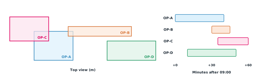
Example 1 Four operators file intents for the same morning
OP-A is our pipeline inspection, OP-B a delivery, OP-C a police mission that the authority ranks higher, and OP-D a mapping job. Each is a box in local coordinates, height and time after 09:00 (hypothetical data).
# 4D operational intents: x, y box (m), height (m) and time (minutes after 09:00)
intents = {
    "OP-A survey":   dict(x=(0, 800), y=(0, 600), z=(0, 90), t=(0, 40), prio=0),
    "OP-B delivery": dict(x=(700, 2000), y=(500, 700), z=(60, 120), t=(30, 45), prio=0),
    "OP-C police":   dict(x=(-500, 300), y=(400, 900), z=(0, 120), t=(35, 60), prio=1),
    "OP-D mapping":  dict(x=(1500, 2500), y=(0, 400), z=(0, 90), t=(10, 50), prio=0),
}

def overlap(a, b):
    return all(max(a[k][0], b[k][0]) < min(a[k][1], b[k][1]) for k in "xyzt")

names = list(intents)
for i, a in enumerate(names):
    for b in names[i + 1:]:
        A, B = intents[a], intents[b]
        if overlap(A, B):
            if A["prio"] != B["prio"]:
                who = (a if A["prio"] < B["prio"] else b) + " (lower priority)"
            else:
                who = "same priority: rule set by the authority"
            shared = {k: (max(A[k][0], B[k][0]), min(A[k][1], B[k][1])) for k in "xyzt"}
            print(f"CONFLICT {a} x {b}: time {shared['t']} min, height {shared['z']} m -> replan: {who}")
        else:
            print(f"clear    {a} x {b}")
CONFLICT OP-A survey x OP-B delivery: time (30, 40) min, height (60, 90) m -> replan: same priority: rule set by the authority
CONFLICT OP-A survey x OP-C police: time (35, 40) min, height (0, 90) m -> replan: OP-A survey (lower priority)
clear OP-A survey x OP-D mapping
clear OP-B delivery x OP-C police
clear OP-B delivery x OP-D mapping
clear OP-C police x OP-D mappingOP-A conflicts with two operators: with OP-B at 30–40 minutes and 60–90 m, where equal priority means the authority’s rules apply, and with OP-C at 35–40 minutes, where OP-A must replan because its priority is lower. OP-A’s easiest fix is to finish the overlapping part before minute 30 or split the area into smaller parts that take less time. Intents wider than necessary cause more conflicts with others.
Remote ID performance requirements
In the United States, 14 CFR 89.310 requires standard remote ID drones to broadcast at least 1 message per second, to broadcast position and altitude no later than 1.0 seconds after measurement, and to be accurate to within 100 ft at 95% probability. ASTM F3411-22a specifies the technical methods for Remote ID and tracking. These requirements determine how fresh and accurate the data are for receivers on the ground, which matters when authorities need to identify which drone is over an area.
Example 2 Will an officer see our drone?
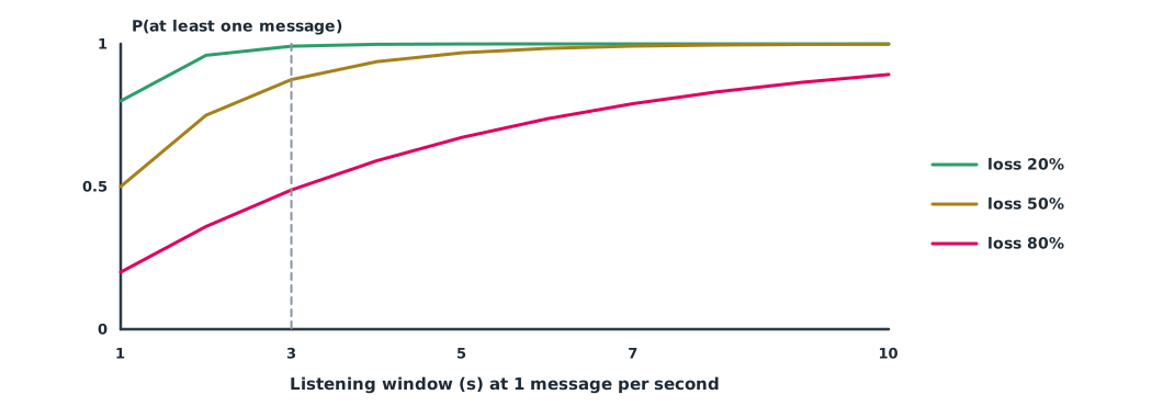
An officer stands beside the pipeline with a broadcast Remote ID receiver. Different environments cause 20%, 50% or 80% of messages to be missed. The drone flies at 20 m/s.
RATE_HZ = 1.0                 # at least 1 message per second (14 CFR 89.310)
LATENCY_S = 1.0               # position broadcast within 1.0 s of measurement
ACC_M = 100 * 0.3048          # position accuracy 100 ft at 95% probability

for loss in (0.2, 0.5, 0.8):  # fraction of messages missed by the receiver (different environments)
    for window in (3, 10):
        n = int(window * RATE_HZ)
        p = 1 - loss ** n
        print(f"loss {loss:.0%}  window {window:>2} s: P(at least one message) = {p:.3f}")

v = 20.0                      # drone speed m/s
worst = v * LATENCY_S + ACC_M
print(f"position uncertainty at {v:.0f} m/s: up to about {worst:.0f} m")
loss 20% window 3 s: P(at least one message) = 0.992
loss 20% window 10 s: P(at least one message) = 1.000
loss 50% window 3 s: P(at least one message) = 0.875
loss 50% window 10 s: P(at least one message) = 0.999
loss 80% window 3 s: P(at least one message) = 0.488
loss 80% window 10 s: P(at least one message) = 0.893
position uncertainty at 20 m/s: up to about 50 mIn the open few messages are missed, and 3 seconds of listening almost guarantees one. But with 80% loss, such as behind trees and buildings, the chance within 3 seconds is below half. The position received may be about 50 m from the true one because of latency plus accuracy. Officers should use this data to identify a drone, not to navigate precisely to it.
Module lab
Lab: intents and identification in the field
- Write the pipeline mission’s operational intent as area, height and time boxes, as narrow as still workable
- Have other groups file hypothetical intents, and check for conflicts with Example 1
- Agree class priority rules as if you were the authority, and resolve the conflicts
- Use a broadcast Remote ID app on a phone to count messages received in the open and behind a building
- Compare the measurements with Example 2 and summarise the limits of real-world use
Common mistakes
Watch out
- Filing intents wider than necessary in area and time
- Checking overlap only on the map, forgetting height and time
- Assuming the standard already sets priority
- Treating Remote ID positions as precise
- Citing US requirements as Thai requirements
Summary
- USSs detect conflicts between operational intents in area, height and time
- ASTM F3548-21 leaves priority rules to the authority
- Part 89 requires at least 1 message per second, latency within 1.0 s and 100 ft accuracy
- Message reception probability and position uncertainty determine what the data can be used for
Check your understanding
- Two intents overlap on the map but not in time. Is that a conflict?
- Who sets priority when intents conflict under ASTM F3548-21?
- What minimum broadcast rate does Part 89 require?
- With 50% message loss and 4 seconds of listening, what is the chance of at least one message?
- A drone flying at 15 m/s with 1 s latency and 30 m accuracy may be off by about how much?
Answers
- No; they must overlap in area, height and time
- The competent authority
- At least 1 message per second
- About m
Key formulas
| Two intervals overlap | |
| Chance of at least one message |
Key references
- International Civil Aviation Organization. (2023). Unmanned aircraft systems traffic management (UTM): A common framework with core principles for global harmonization (4th ed.). ICAO. link
- ASTM International. (2021). Standard specification for UAS traffic management (UTM) UAS service supplier (USS) interoperability (ASTM F3548-21). link
- 14 CFR § 89.310 – Minimum performance requirements for standard remote identification unmanned aircraft. (Legal Information Institute, Cornell Law School). link
- ASTM International. (2022). Standard specification for remote ID and tracking (ASTM F3411-22a). link
- Federal Aviation Administration. Remote identification of unmanned aircraft, 14 C.F.R. Part 89 (compliance date September 16, 2023). link
Further reading
Study the assigned knowledge units in advance, review media and take the module quiz
In class / field
Lab or field practice from worksheets with a safety checklist
Learning evidence: Checked worksheets and quiz results