Problem identification
UAT 493 Unmanned Aircraft Systems and Automation Technology Capstone Project I
Lesson
By the end of this module you will be able to
- Identify the project's stakeholders and the needs of each group
- Write a solution-free problem statement and a concept of operations (ConOps) for the system
- Keep an assumption register that separates what is known from what must be checked
- Size the mission from stated assumptions and distinguish validation from verification
Why this matters
Most failed projects do not fail because the engineering was poor. They fail because the team solved the wrong problem. A team that starts from “we want to build an AI inspection drone” often ends up with a system that works but that nobody wants to use. A team that starts from a real user problem knows what to build and knows when it has succeeded. The ABET criteria for engineering technology programs require a project that integrates technical and non-technical skills to solve a problem, which is exactly what this course does.
The whole course follows one hypothetical case: an automated drone system that inspects a 2 km irrigation canal, extended from the mission-concept example in the drone knowledge base. This course is the first project semester and ends with a project proposal; building and testing happen in the next project semester. Every module has a project deliverable. The Python code for every module can be downloaded from /downloads/uat-493/.
Stakeholders
A stakeholder is anyone affected by, or with authority over, the project, not only the customer.
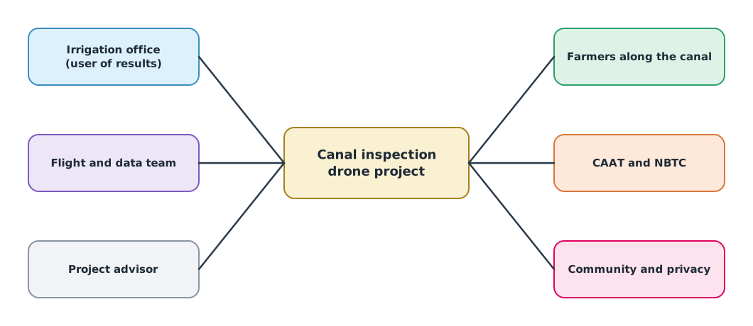
Stakeholder needs can conflict. The irrigation office wants detailed images, while the community along the canal worries about their homes being photographed. Identifying this early lets the design accommodate it, for example by limiting the imaging area and deleting unrelated images.
Problem statement and ConOps
A good problem statement says who has what problem, what the impact is and how it can be measured, without naming a solution.
- Poor: “We need an AI drone to inspect the canal” (the solution is already chosen)
- Better: “The irrigation office only finds damage to canal banks after water has leaked, because staff can walk the 2 km line only once a month, so repairs are late and water is lost”
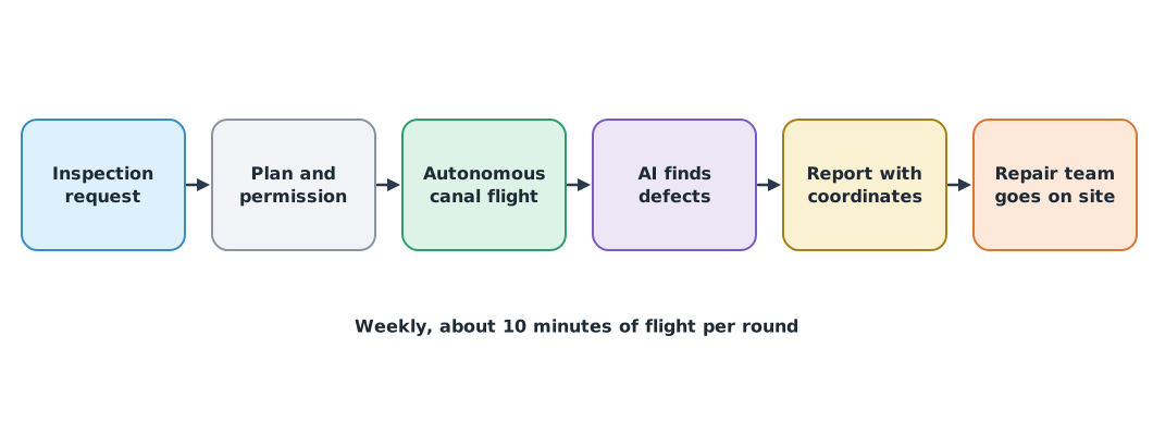
A concept of operations (ConOps), as described in the NASA Systems Engineering Handbook, explains how the system will be used to meet the need, usually told in time order from the user’s point of view.
Assumption register and mission sizing
Every estimate at this stage rests on assumptions. An assumption register records each one with its data owner, how it will be checked and its status, so that an assumption does not quietly become a “fact” that nobody checked.
Example 1. Sizing the mission from assumptions
import math

assumptions = {  # value, data owner, status
    "canal length m": (2000, "irrigation office map", "checked"),
    "corridor width m": (60, "site visit", "to check"),
    "footprint across track m": (90, "camera spec at 60 m height", "to check"),
    "footprint along track m": (60, "camera spec at 60 m height", "to check"),
    "forward overlap": (0.75, "mapping practice for the team", "assumed"),
    "ground speed m/s": (5.0, "flight test", "to check"),
}
v = {k: val for k, (val, _, _) in assumptions.items()}
spacing = v["footprint along track m"] * (1 - v["forward overlap"])
passes = math.ceil(v["corridor width m"] / v["footprint across track m"])
photos = passes * (math.floor(v["canal length m"] / spacing) + 1)
flight_min = passes * v["canal length m"] / v["ground speed m/s"] / 60 + 3     # + 3 min take-off, landing and transit
print(f"photo spacing {spacing:.0f} m, passes {passes}, photos {photos}, flight ≈ {flight_min:.1f} min per round")
print(f"weekly for a year: {52 * photos:,} photos, about {52 * photos * 25 / 1000:.0f} GB at 25 MB each")
unchecked = [k for k, (_, _, st) in assumptions.items() if st != "checked"]
print(f"{len(unchecked)} of {len(assumptions)} assumptions not yet checked:", ", ".join(unchecked))
photo spacing 15 m, passes 1, photos 134, flight ≈ 9.7 min per round
weekly for a year: 6,968 photos, about 174 GB at 25 MB each
5 of 6 assumptions not yet checked: corridor width m, footprint across track m, footprint along track m, forward overlap, ground speed m/sThe estimate says one round of about 10 minutes is enough, and a year of data is large enough to need a storage plan. But only one assumption has been checked. If the real corridor is wider than 90 m, the number of flight lines doubles, so the register says a site survey comes first.
Validation and verification
The NASA handbook separates the two terms with short questions. Verification asks “did we build it right, according to the requirements?” Validation asks “did we build the right thing?”, that is, does it meet the real user need. This module lays the ground for validation; modules 2–5 make verification possible.
Module lab
Project deliverable: mission concept and assumption register
- Each team chooses a real problem involving UAS or automation (or uses the irrigation canal case) and interviews at least two stakeholder groups
- Write a problem statement with no solution in it, and have another team check for hidden solutions
- Draw a stakeholder map and a ConOps like Figures 1 and 2 for your own project
- Build an assumption register of at least 10 items, use Example 1 as a template to size the mission, and identify which assumptions must be checked first
- Make an initial regulatory check, for example whether the mission falls under general conditions or needs a Specific authorisation, and whether the CAAT PDRA guidance applies
Common mistakes
Watch out
- Starting from the technology you want to use instead of the user’s problem
- Talking to only one customer and forgetting other stakeholders such as the community or the regulator
- A problem statement with a hidden solution
- Using assumed numbers without recording them as assumptions
- Believing that passing verification means the user is satisfied
Summary
- Start from stakeholders and real needs, not from technology
- A problem statement gives a measurable impact without a solution; a ConOps tells the use of the system in time order
- An assumption register separates what is known from what must be checked, and shows what to check first
- Verification means building it right to the requirements; validation means building the right thing
Check your understanding
- Is “we need a drone with a thermal camera” a good problem statement? Why?
- The image is 60 m long along track with 80% overlap. What is the photo spacing?
- A flight line is 1,500 m long with a 15 m photo spacing. How many photos are needed?
- Is the question “did we build the right thing?” verification or validation?
- Besides the assumed value, what should an assumption register record?
Answers
- No, because it already states a solution and does not say who has what problem or what the impact is
- m
- photos
- Validation
- The data owner, how it will be checked, and whether it has been checked yet
Key formulas
| Photo spacing with overlap | |
| Photos per flight line |
Key references
- National Aeronautics and Space Administration. (2016). NASA systems engineering handbook (NASA/SP-2016-6105 Rev 2). link
- INCOSE. (2023). INCOSE systems engineering handbook: A guide for system life cycle processes and activities (5th ed.). Wiley. link
- Dym, C. L., Little, P., & Orwin, E. J. (2013). Engineering design: A project-based introduction (4th ed.). Wiley. link
- ABET. (2024). Criteria for accrediting engineering technology programs, 2025–2026. link
- สำนักงานการบินพลเรือนแห่งประเทศไทย. (2568). แนวปฏิบัติในการขอปฏิบัติการบินอากาศยานซึ่งไม่มีนักบินโดยใช้การประเมินความเสี่ยงที่เป็นไปตามเงื่อนไขที่กำหนดสำหรับการบินเกินกว่าระยะสายตา (CAAT-GM-UAS-PDRA101 ปรับปรุงครั้งที่ 00). link
Further reading
Study the assigned knowledge units in advance, review media and take the module quiz
Defining the mission concept
Brief: questions, deliverables and team roles
In class / field
Team project work, advisor meetings and progress presentations
Learning evidence: Project milestone deliverables