Public safety
UAT 364 Unmanned Aircraft Systems Technology for Public Safety and Emergency Management
Lesson
By the end of this module you will be able to
- Explain the roles of drones before, during and after a disaster
- Explain the incident command system and where the UAS unit sits in it
- Plan drones and batteries for a continuous mission
- Prepare baseline data and the team before a disaster, and identify legal and data protection requirements
Why this matters
When a flash flood cuts roads and people are reported missing, rescue teams need an aerial view as fast as possible. Drones provide images within minutes without risking responders’ lives. But if a drone team flies without coordinating with the command post, the images may never reach those who need them, or the drone may get in the way of a rescue helicopter. Murphy’s Disaster Robotics (2014) documents dozens of real robot deployments in disasters and shows that technology helps when it fits the responders’ way of working.
The whole course follows one hypothetical case: a flash flood in a district, with one person missing in riverside forest; the incident command post asks the provincial drone team for support. All numbers are synthetic training data, not a real event. The Python code for every module can be downloaded from /downloads/uat-364/.
Drone roles across the disaster timeline
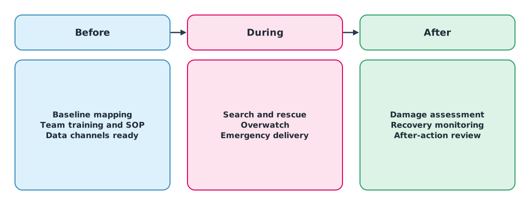
A real example: after the 2019 cyclones in Mozambique, WFP used drones with AI to count damaged houses, and the drone pilots were local staff that WFP had trained before the disaster. Preparing people before a disaster matters as much as the aircraft.
The incident command system
Incidents involving many agencies need a single command structure. The incident command system (ICS) in NIMS, third edition (FEMA, 2017), has an Incident Commander and four main sections: Operations, Planning, Logistics and Finance/Administration. The drone team is not an independent unit but a resource within this structure. Thailand’s framework is the National Disaster Prevention and Mitigation Plan 2021–2027 of the Department of Disaster Prevention and Mitigation, and work with urban search and rescue teams follows the UN INSARAG Guidelines 2020.
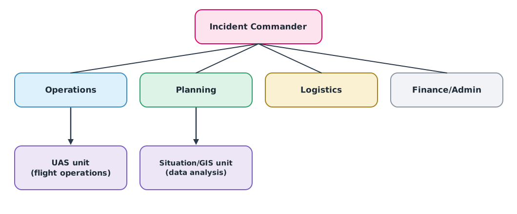
Placing the UAS unit under Operations and sending data to the situation unit under Planning is one example; agencies may arrange it differently. What matters is that everyone knows who tasks the drone team and who receives the data.
Resources for continuous missions
Overwatch of a flooded area may need a drone in the air continuously for hours. One battery flies for a limited time and takes longer to charge than to fly, so the team must work out batteries and aircraft before deploying.
Example 1. Batteries for 4 hours of overwatch
Assumed values: 25 minutes of flight per battery, 5 minutes to swap, 60 minutes to charge.
import math

MISSION_MIN, FLIGHT_MIN, SWAP_MIN, CHARGE_MIN = 240, 25, 5, 60

sorties = math.ceil(MISSION_MIN / FLIGHT_MIN)
per_slot = math.ceil((FLIGHT_MIN + SWAP_MIN + CHARGE_MIN) / FLIGHT_MIN)
print(f"{sorties} sorties over {MISSION_MIN} min")
print(f"batteries in rotation per aircraft slot: {per_slot} (+1 spare = {per_slot + 1})")
print("no gap during battery swaps needs 2 aircraft alternating "
      f"-> {2 * (per_slot + 1)} batteries and a charger that keeps up")
10 sorties over 240 min
batteries in rotation per aircraft slot: 4 (+1 spare = 5)
no gap during battery swaps needs 2 aircraft alternating -> 10 batteries and a charger that keeps upWith one drone there is a gap at every battery swap, so a truly continuous mission needs two aircraft alternating, plus a power source for charging in a flooded area that may have lost mains power.
Preparing data and the team before a disaster
The knowledge unit on preparedness notes that post-event images are easier to interpret with pre-event baseline data carrying dates and coordinate systems, such as community boundaries, buildings, roads and staging areas. Old data may not match the current situation, so the age of every layer must be known.
Example 2. Checking age and coordinate system of baseline data
from datetime import date

EVENT = date(2026, 9, 20)
layers = [  # layer name, data date, coordinate system
    ("village boundaries", date(2025, 11, 2), "EPSG:32647"),
    ("building footprints", date(2023, 5, 14), "EPSG:32647"),
    ("roads", date(2026, 6, 30), "EPSG:4326"),
    ("staging areas", None, None),
]
for name, d, crs in layers:
    issues = []
    if d is None:
        issues.append("date unknown")
    elif (EVENT - d).days > 365:
        issues.append(f"{(EVENT - d).days} days old")
    if crs is None:
        issues.append("CRS unknown")
    print(f"{name:<20} {'OK' if not issues else ', '.join(issues)}")
village boundaries OK
building footprints 1225 days old
roads OK
staging areas date unknown, CRS unknownThe building layer is over three years old and may miss new houses, and staging areas with no date or coordinate system must be checked before use. The road layer passes the age check but uses EPSG:4326, unlike the other layers, so it must be transformed before overlaying (this example code does not yet check for coordinate system differences).
Law and data protection
An emergency does not automatically exempt a team from permission. The team must check CAAT requirements and coordinate through the local command post (see UAT 313). Mission images may show faces, homes and the locations of victims. The ICRC Handbook on Data Protection in Humanitarian Action (3rd ed., 2024) has a chapter on drones, highlighting personal data, data security and community trust (details in module 5). NIST’s standard test methods for small drones can be used to design pilot skill training.
Module lab
Lab: preparing a disaster drone team
- Draw the ICS chart for the hypothetical incident, showing the drone team, who tasks it and who receives its data
- Use Example 1 with the lab’s drones and batteries to plan 4 hours of continuous overwatch, including backup power
- Gather baseline data for an area near the university and check it with Example 2
- List the equipment and the person responsible for each item
- Practise handing files to a classmate with the internet off, and record what was missing
Common mistakes
Watch out
- Flying without going through the command post
- Assuming an emergency exempts the team from permission
- Bringing too few batteries or no way to charge them
- Using baseline data without knowing its age and coordinate system
- Publishing images of victims on public channels
Summary
- Drones have roles before, during and after a disaster; preparing people matters as much as the aircraft
- The drone team is a resource under the incident command system; everyone must know who tasks it and who receives its data
- Continuous missions need a plan for aircraft, batteries and charging
- Baseline data must have known age and coordinate system, and emergencies do not waive permission or data protection
Check your understanding
- A 3-hour mission with 20 minutes per battery needs how many sorties?
- With 20 minutes of flight, 5 minutes to swap and 50 minutes to charge, how many batteries rotate per aircraft slot?
- What are the four main ICS sections under NIMS?
- Why does continuous overwatch need two drones?
- Does an emergency exempt a team from flight permission?
Answers
- sorties
- batteries
- Operations, Planning, Logistics and Finance/Administration
- A single drone leaves a gap at every battery swap
- Not automatically; check CAAT requirements and coordinate with the command post
Key formulas
| Sorties for a continuous mission | |
| Batteries in rotation per aircraft slot |
Key references
- Federal Emergency Management Agency. (2017). National incident management system (3rd ed.). U.S. Department of Homeland Security. link
- กรมป้องกันและบรรเทาสาธารณภัย. (2564). แผนการป้องกันและบรรเทาสาธารณภัยแห่งชาติ พ.ศ. 2564–2570. กระทรวงมหาดไทย. link
- INSARAG. (2020). INSARAG guidelines 2020 (Vols. I–III). United Nations OCHA. link
- Murphy, R. R. (2014). Disaster robotics. MIT Press. link
- World Food Programme. (2020, January 31). Joining the dots: How AI and drones are transforming emergencies. link
- Marelli, M. (Ed.). (2024). Drones/UAVs and remote sensing. In Handbook on data protection in humanitarian action (3rd ed., ch. 7). ICRC; Cambridge University Press. link
- สำนักงานการบินพลเรือนแห่งประเทศไทย. (2569). ประกาศ กพท. เรื่อง หลักเกณฑ์และวิธีการในการอนุญาตให้ผู้บังคับหรือปล่อยอากาศยานซึ่งไม่มีนักบิน ประเภทอากาศยานที่ควบคุมการบินจากภายนอก ที่มีน้ำหนักไม่เกิน 25 กิโลกรัม ปฏิบัติแตกต่างไปจากเงื่อนไขที่กำหนด พ.ศ. 2569 (มีผล 17 พฤษภาคม 2569). link
- National Institute of Standards and Technology. Standard test methods for small unmanned aircraft systems (aerial drone tests). link
Further reading
Study the assigned knowledge units in advance, review media and take the module quiz
In class / field
Intensive lab and field practice recorded in a lab notebook
Learning evidence: Lab notebook signed by the instructor