Agricultural drones
UAT 365 Unmanned Aircraft Systems Technology for Smart Agriculture and Remote Sensing
Lesson
By the end of this module you will be able to
- Explain precision agriculture and the roles of survey drones and spray drones
- Explain how plants reflect different wavelengths and how this separates healthy from stressed plants
- Compare drones, satellites and ground scouting for resolution, frequency and cost
- Convert between rai, ngan, square wa and hectares, and identify Thai requirements for agricultural drones
Why this matters
A farmer managing a 30-rai field cannot walk all of it often, and usually notices a problem only once leaves have turned yellow, which may be too late. A drone with a multispectral camera sees plant stress in wavelengths the human eye cannot, and a spray drone applies fertiliser or chemicals only where needed. But a beautiful image of the field helps no one unless you understand what its numbers mean and what decision follows.
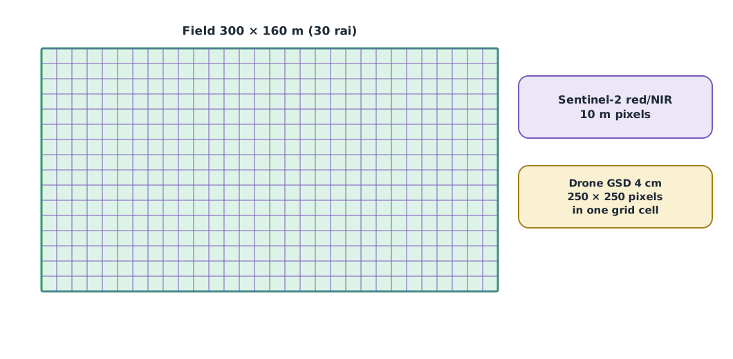
The whole course follows one hypothetical case: a 300 × 160 m (30 rai) rice field of an agricultural cooperative, monitored with a multispectral drone, followed by zone-based liquid fertiliser application. All numbers are synthetic training data. The Python code for every module can be downloaded from /downloads/uat-365/.
Precision agriculture
The International Society of Precision Agriculture (ISPA) gives a short definition: precision agriculture is a management strategy that takes account of temporal and spatial variability to improve the sustainability of agricultural production. Put simply, no field is the same in every square metre. One corner is saline, another waterlogged, another short of nitrogen. Applying the same amount of fertiliser everywhere wastes it where it is not needed and leaves too little where it is.
The FAO and ITU report (2018) describes many roles for drones in agriculture. This course groups them in two:
- Survey drones carry RGB, multispectral or thermal cameras to map fields and monitor crop health (modules 2, 3 and 5)
- Spray and spreading drones carry a liquid tank or seed hopper to apply fertiliser, crop protection products or seed (module 4)
How plants reflect light
NASA Earth Observatory explains that chlorophyll in leaves strongly absorbs visible light, especially red and blue, while the cell structure of the leaf strongly reflects near-infrared (NIR) light. A healthy plant therefore reflects little red and much NIR. When a plant is stressed, chlorophyll falls and leaf structure changes, so red reflectance rises and NIR falls. The steep rise in reflectance between red and NIR is called the red edge.
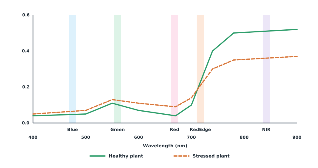
A multispectral camera such as the MicaSense RedEdge-P has the five bands shown in Figure 1: blue 475 nm, green 560 nm, red 668 nm, red edge 717 nm and NIR 842 nm. Each band is only 12–57 nm wide, so it measures reflectance in the chosen range more precisely than an ordinary RGB camera.
Drone, satellite or walking the field
ESA’s Sentinel-2 provides red and NIR bands at 10 m resolution and revisits the same place every 5 days with two satellites. The data is free, but often cloud-covered in the rainy season. A drone resolves centimetres and can fly under cloud, but needs a pilot and covers far less area.
Example 1. Pixels per rai, and satellite pixels that are “all field”
FIELD_L, FIELD_W, RAI = 300, 160, 1600      # m, m, m² per rai

for name, gsd in (("drone 2 cm", 0.02), ("drone 4 cm", 0.04), ("Sentinel-2 10 m", 10.0)):
    print(f"{name:<16} {RAI / gsd ** 2:>12,.0f} pixels per rai")

def pixels(length, offset, size=10):
    first = offset // size
    last = (offset + length - 1e-9) // size
    inside = sum(1 for i in range(int(first), int(last) + 1)
                 if i * size >= offset and (i + 1) * size <= offset + length)
    return inside, int(last - first + 1)

nx_in, nx_all = pixels(FIELD_L, 5)
ny_in, ny_all = pixels(FIELD_W, 5)
print(f"field shifted 5 m from the satellite grid: {nx_in * ny_in} pixels fully inside, "
      f"{nx_all * ny_all} touching the field")
drone 2 cm 4,000,000 pixels per rai
drone 4 cm 1,000,000 pixels per rai
Sentinel-2 10 m 16 pixels per rai
field shifted 5 m from the satellite grid: 435 pixels fully inside, 527 touching the fieldIf the field does not line up with the satellite pixel grid, edge pixels mix in bunds, roads or neighbouring fields, so there are fewer “pure” pixels than expected. At 4 cm GSD the drone has a million pixels per rai, but that is a huge amount of data to process. The highest resolution is not necessarily the best choice; choose to fit the question.
| Drone | Sentinel-2 satellite | Ground scouting | |
|---|---|---|---|
| Resolution | Centimetres | 10–60 m depending on band | Plant by plant |
| Frequency | On demand, weather permitting | Every 5 days if cloud-free | As labour allows |
| Cloud | Can fly beneath it | Blocked by it | Not affected |
| Best for | Medium fields needing detail | Wide-area overview and long-term trends | Confirming causes (ground truth) |
The three work together. Drone or satellite images show “where something is wrong”; walking into the field shows “why”.
Area units and Thai requirements
The Weights and Measures Act B.E. 2542 (1999) defines 1 rai = 1,600 m², 1 ngan = 400 m² and 1 square wa = 4 m². International spray and fertiliser rates usually use hectares (10,000 m²).
Example 2. Converting area to rai, ngan, square wa and hectares
def thai_area(m2):
    rai, rest = divmod(m2, 1600)
    ngan, rest = divmod(rest, 400)
    return int(rai), int(ngan), rest / 4

for length, width in ((300, 160), (250, 137)):
    area = length * width
    rai, ngan, wa = thai_area(area)
    print(f"{length} x {width} m = {area:,} m2 = {rai} rai {ngan} ngan {wa:g} sq wa = {area / 10_000:.3f} ha")
300 x 160 m = 48,000 m2 = 30 rai 0 ngan 0 sq wa = 4.800 ha
250 x 137 m = 34,250 m2 = 21 rai 1 ngan 62.5 sq wa = 3.425 haBefore using agricultural drones in Thailand, check at least three sets of requirements:
- NBTC: register the drone’s radio equipment
- CAAT: register and obtain permission for the pilot under the rules in force (see UAT 313)
- Department of Agriculture: in December 2024 it launched a standard operating practice for spraying with agricultural unmanned aircraft and ID cards for contracted spray operators who pass its training. Spray operators must check the latest details directly with the Department (module 4)
Module lab
Lab: taking a brief from a farmer
- Interview a farmer or cooperative officer: what decisions must they make in the field, when, and what information do they use now?
- Measure the training field from a satellite image or map, and use Example 2 to convert it to rai and hectares
- Open a Sentinel-2 image of the same field, count pixels fully inside the field and pixels on the edge, and compare with Example 1
- Write a one-page brief: the farmer’s question, the data needed, and whether to use a drone, satellite or ground scouting, with reasons
- Check the flight and registration requirements for the lab drone and record them in the lab notebook
Common mistakes
Watch out
- Starting from technology instead of the farmer’s question
- Thinking a colourised RGB image is a multispectral image
- Always choosing the highest resolution without considering processing time and cost
- Concluding causes from images alone without visiting the field
- Mixing rai and hectares when calculating rates
Summary
- Precision agriculture manages the variability within a field rather than treating it uniformly
- Healthy plants reflect little red and much NIR, stressed plants the reverse; multispectral cameras measure this difference
- Drones, satellites and ground scouting complement each other; choose to fit the question
- 1 rai = 1,600 m², and agricultural drone use must meet NBTC, CAAT and Department of Agriculture requirements
Check your understanding
- How many rai is a 200 × 120 m field?
- How do red and NIR reflectance usually change when a plant is stressed?
- How many pixels are in one rai at 5 cm GSD?
- What are the main advantage and limitation of Sentinel-2 compared with a drone?
- How many rai are 5 hectares?
Answers
- rai
- Red reflectance rises and NIR falls
- pixels
- It is free and revisits every 5 days over wide areas, but its resolution is 10 m or coarser and it is blocked by cloud
- rai
Key formulas
| Thai area units | |
| Pixels per area |
Key references
- International Society of Precision Agriculture. (2024). Precision agriculture definition. link
- Food and Agriculture Organization & International Telecommunication Union. (2018). E-agriculture in action: Drones for agriculture. FAO. link
- NASA Earth Observatory. (2000, August 30). Measuring vegetation (NDVI & EVI). link
- European Space Agency. S2 mission. SentiWiki (Copernicus). link
- MicaSense. RedEdge-P multispectral sensor [Product specifications]. EagleNXT. link
- พระราชบัญญัติมาตราชั่งตวงวัด พ.ศ. 2542 (บัญชีท้ายมาตรา 9 หน่วยพื้นที่). link
- กรมวิชาการเกษตร. (2567, 16 ธันวาคม). กรมวิชาการเกษตรเปิดตัวมาตรฐานการปฏิบัติงานการพ่นสารด้วยอากาศยานไร้คนขับทางการเกษตรและบัตรประจำตัวผู้รับจ้างพ่น [ข่าวประชาสัมพันธ์]. link
- สำนักงานการบินพลเรือนแห่งประเทศไทย. (2569). ประกาศ กพท. เรื่อง หลักเกณฑ์และวิธีการในการอนุญาตให้ผู้บังคับหรือปล่อยอากาศยานซึ่งไม่มีนักบิน ประเภทอากาศยานที่ควบคุมการบินจากภายนอก ที่มีน้ำหนักไม่เกิน 25 กิโลกรัม ปฏิบัติแตกต่างไปจากเงื่อนไขที่กำหนด พ.ศ. 2569 (มีผล 17 พฤษภาคม 2569). link
- สำนักงาน กสทช. ระบบลงทะเบียนอากาศยานซึ่งไม่มีนักบิน (โดรน). link
Further reading
Study the assigned knowledge units in advance, review media and take the module quiz
In class / field
Intensive lab and field practice recorded in a lab notebook
Learning evidence: Lab notebook signed by the instructor