Propulsion, control and navigation
UAT 301 Unmanned Aircraft Systems Technology
Lesson
By the end of this module you will be able to
- Estimate the flight power of multirotor, fixed-wing and VTOL aircraft from physics
- Compare the endurance and mapping area per flight of the three architectures
- Explain the layers of flight control and the flight modes
- Compute DOP from satellite positions and estimate GNSS position error
Why this matters
Endurance and position accuracy are the two numbers that decide whether a drone can do a mission. Sellers usually quote the maximum endurance measured in the best conditions. An engineer must be able to estimate it from physics to compare architectures fairly. This module continues the case: the provincial disaster prevention centre must map 4 km² of flooding. The drone knowledge base’s unit on design and system integration recommends turning the mission into mass and power budgets before choosing a propulsion set.
Flight power of the three architectures
A multirotor must produce lift equal to its weight with its rotors at all times. Leishman’s momentum theory gives the ideal hover power , where is the total rotor disk area. Real rotors lose more than this, so divide by the figure of merit (FM), about 0.5–0.7 for small rotors (Bauersfeld and Scaramuzza, 2022), and by the motor and ESC efficiency.
A fixed-wing aircraft uses its wing for lift, and the propeller only overcomes drag, which equals weight divided by the lift-to-drag ratio . The power is therefore divided by the propeller and electrical efficiencies (Fahlstrom and colleagues).
A VTOL aircraft takes off and lands vertically with lift rotors and cruises on its wing, so it carries lift motors that do nothing during cruise. Its mass is higher and its lower.
Example 1 Endurance and area per flight with the same battery
A 6S 10 Ah battery (22.2 V) with 80% of its energy usable. The multirotor weighs 3.0 kg with 15-inch propellers; the fixed-wing weighs 3.0 kg with 10; the VTOL weighs 3.6 kg with 8, 13-inch lift rotors and 2 minutes of hover in total. Mapping uses a 150 m image swath with 70% side overlap and a 20% energy reserve (hypothetical values).
import math

G, RHO = 9.81, 1.225
E_USABLE = 22.2 * 10 * 0.8                    # Wh
RESERVE, SWATH, SIDELAP = 0.20, 150, 0.70

def hover_power(m, d_prop, n=4, fm=0.6, eta=0.8):
    thrust = m * G
    area = n * math.pi * (d_prop / 2) ** 2
    return thrust ** 1.5 / math.sqrt(2 * RHO * area) / fm / eta

def cruise_power(m, v, ld, eta=0.6 * 0.85):   # propeller × electrical efficiency
    return m * G * v / ld / eta

def area_km2(cruise_min, v):
    return cruise_min * (1 - RESERVE) * 60 * v * SWATH * (1 - SIDELAP) / 1e6

p_mr = hover_power(3.0, 0.381)
p_fw = cruise_power(3.0, 16, 10)
p_hv, p_cr = hover_power(3.6, 0.33), cruise_power(3.6, 16, 8)
t_mr, t_fw = E_USABLE / p_mr * 60, E_USABLE / p_fw * 60
t_vcruise = (E_USABLE - p_hv * 2 / 60) / p_cr * 60
print(f"multirotor  {p_mr:5.1f} W  {t_mr:5.1f} min  {area_km2(t_mr, 10):.2f} km2 per flight")
print(f"fixed-wing  {p_fw:5.1f} W  {t_fw:5.1f} min  {area_km2(t_fw, 16):.2f} km2 per flight")
print(f"VTOL hover {p_hv:.0f} W, cruise {p_cr:.1f} W  {t_vcruise + 2:5.1f} min  {area_km2(t_vcruise, 16):.2f} km2 per flight")
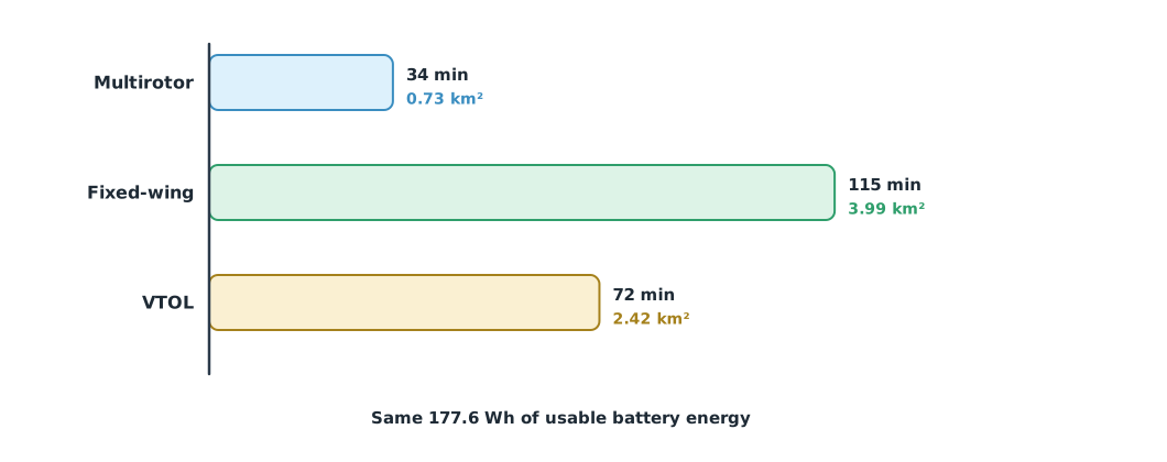
multirotor 314.7 W 33.9 min 0.73 km2 per flight
fixed-wing 92.3 W 115.4 min 3.99 km2 per flight
VTOL hover 478 W, cruise 138.5 W 72.0 min 2.42 km2 per flightThe fixed-wing flies more than three times as long as the multirotor because it needs far less power. The VTOL uses very high power while hovering but only briefly, so its endurance falls between the two. These are first estimates: a real multirotor in forward flight uses different power from hover, and strong wind shortens endurance for every type.
Flight control
Autopilots such as PX4 and ArduPilot control in layers (covered in detail in UAT 206): the innermost layer controls angular rates, then attitude, then velocity and position, and the outermost layer is mission navigation. The flight mode decides which layer takes the pilot’s commands. In an attitude mode the pilot commands the tilt angles directly; in position hold the system holds position using GNSS; and in mission mode it flies the waypoints. When GNSS degrades, a good system drops to a mode that does not depend on position, and pilots must be fluent in flying that mode.
Navigation with GNSS
The drone knowledge base’s GNSS unit stresses separating position data from the control system so that the aircraft state is read in context. Position error comes from two parts: the range error to each satellite (the user equivalent range error, UERE) and the satellite geometry, measured by DOP (dilution of precision). Following Groves, horizontal error is about . The GPS SPS Performance Standard (5th edition, 2020) sets the signal-in-space URE at no more than 7.0 m (95%) for each satellite and no more than 2.0 m (95%) averaged over the constellation, and sets the global average position accuracy at no more than 8 m horizontal (95%). The total error a user sees also includes atmospheric, multipath and receiver effects.
Example 2 DOP in the open and between buildings
DOP is computed from the satellite geometry matrix . Each row is the unit vector from the user to a satellite (east, north, up) followed by 1 for the receiver clock, and .
import math
import numpy as np

def dop(sats):                                # (azimuth, elevation) degrees
    rows = []
    for az, el in sats:
        a, e = math.radians(az), math.radians(el)
        rows.append([math.cos(e) * math.sin(a), math.cos(e) * math.cos(a), math.sin(e), 1.0])
    g = np.array(rows)
    q = np.linalg.inv(g.T @ g)
    return math.sqrt(q[0, 0] + q[1, 1]), math.sqrt(q[2, 2])

open_sky = [(0, 60), (70, 35), (140, 25), (200, 50), (260, 30), (320, 20), (100, 75), (230, 15)]
urban = [(40, 70), (100, 55), (160, 60), (210, 65), (80, 80)]
UERE = 3.0                                    # m (1 sigma), assumed for a typical receiver
for name, sats in (("open sky", open_sky), ("urban canyon", urban)):
    h, v = dop(sats)
    print(f"{name:<12} {len(sats)} sats  HDOP {h:.2f}  VDOP {v:.2f}  horizontal ~ {h * UERE:.1f} m (1 sigma)")
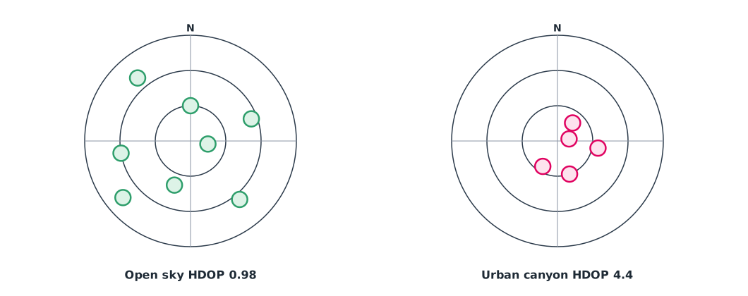
open sky 8 sats HDOP 0.98 VDOP 1.63 horizontal ~ 2.9 m (1 sigma)
urban canyon 5 sats HDOP 4.36 VDOP 14.44 horizontal ~ 13.1 m (1 sigma)Between tall buildings, the visible satellites are all at high elevation and on one side, so the horizontal error grows several times and the vertical error is worse still. For centimetre-level work, such as mapping without ground control points, use RTK or PPK, which use a base station to remove common errors.
Module lab
Lab: check endurance and position quality
- Weigh the programme’s training drone with its battery, measure the propellers, and estimate hover power with Example 1
- Hover in open, calm conditions for 3 minutes, read electrical power from the log, compare it with the estimate, and work out the matching FM
- Open QGroundControl and compare the satellite count and HDOP in an open field and next to a tall building
- Log position with the drone stationary for 5 minutes at both places and compute the spread of positions
- Switch from position hold to an attitude mode in safe conditions under the instructor’s supervision
Common mistakes
Watch out
- Trusting brochure endurance without estimating it yourself
- Forgetting the energy reserve when computing area per flight
- Thinking VTOL gets the benefits of both types at no cost
- Looking only at the number of satellites, not the geometry and DOP
- Not practising flight in modes that do not use GNSS
Summary
- A multirotor’s power follows momentum theory and a fixed-wing’s follows , so the fixed-wing flies much longer
- VTOL trades vertical take-off for extra mass and drag
- Autopilots control in layers, and the flight mode decides which layer assists the pilot
- GNSS error is about HDOP × UERE; satellite geometry matters as much as their number
Check your understanding
- If a multirotor’s mass doubles, by what factor does ideal hover power increase?
- A 2 kg fixed-wing at 15 m/s with 12 and overall efficiency 0.5 needs how much power?
- Why does a VTOL fly less than a fixed-wing with the same battery?
- HDOP 1.5 and UERE 3 m. What is the approximate horizontal error?
- Why does DOP get worse between tall buildings?
Answers
- times
- W
- It carries lift motors and uses high power while hovering, so its mass is higher and its lower
- m (1σ)
- Fewer satellites are visible and they sit in a narrow range of directions, so the geometry is poor
Key formulas
| Hover power from momentum theory | |
| Fixed-wing cruise power | |
| GNSS position error |
Key references
- Leishman, J. G. (2006). Principles of helicopter aerodynamics (2nd ed.). Cambridge University Press.
- Bauersfeld, L., & Scaramuzza, D. (2022). Range, endurance, and optimal speed estimates for multicopters. IEEE Robotics and Automation Letters (arXiv:2109.04741). link
- Fahlstrom, P. G., Gleason, T. J., & Sadraey, M. H. (2022). Introduction to UAV systems (5th ed.). Wiley. link
- Quan, Q. (2017). Introduction to multicopter design and control. Springer Singapore. link
- Groves, P. D. (2013). Principles of GNSS, inertial, and multisensor integrated navigation systems (2nd ed.). Artech House. link
- U.S. Department of Defense. (2020). Global Positioning System standard positioning service performance standard (5th ed.). link
- PX4 Autopilot. PX4 user and developer guide. link
- ArduPilot Dev Team. ArduPilot documentation. link
Further reading
Study the assigned knowledge units in advance, review media and take the module quiz
Designing and integrating drone systems
GNSS and constrained navigation
In class / field
Lab or field practice from worksheets with a safety checklist
Learning evidence: Checked worksheets and quiz results